Three examples of using ICT to support traditionally hard to teach geography topics, including using data loggers, a virtual field trip, and using readily available geographic information systems (GIS).
A geography teacher at The Friary School in Lichfield, takes a Year 10 group out into the school grounds where they investigate the local microclimate using data loggers and probes.
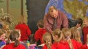
Next, at Notre Dame School in Sheffield, a Year 8 group go on a classroom-based virtual field trip, using a range of photographic and mapping resources on the school's learning platform.
Finally, geography teacher Robert Lang and his students at Five Ways King Edward VI School in Birmingham use a range of readily available GIS applications to analyse global statistics, investigate coastal erosion, and design and map infrastructure improvements in their local area.